Irish Maps & Gazetteers
I love maps. Whilst this website grew from wanting to organise my Irish genealogical bookmarks, I actually wanted to create a whole new way of finding evidence by using maps to explore instead of filling in endless search boxes - "letterbox Scrabble!". However, as this idea is currently well beyond my programming skills, I hunt online for old maps to answers questions and pose new ones.
 Kilkenny Streets - Image by Wiggy
For example, street names have a habit of changing, so try finding them on old maps e.g. Dublin 1798, and cross reference them with later maps. The same is true of many other places and I will continue to look out for good resources.
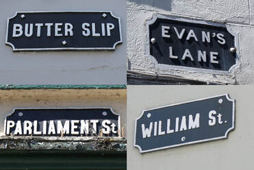
Incidentally, this composite of lovely old street signs comes from a trip I made to Kilkenny a few years ago. Parliament St. was once called Coal Market, where my Empson ancestors lived and traded, and Evans is another family name. Clues everywhere!
Butter Slip? No doubt an historic reference to the manufacture of dairy products but it just made me laugh...! You can find some of these streets on this 1780 Kilkenny City Map which I found on Wikipedia - always worth just having a general hunt around online to see what turns up.
 William Petty's Map of Ireland
How and why has Ireland been surveyed and mapped?
Ireland has been surveyed and mapped at many times in its long history but it is probably the resources that survive from the 17th century onwards that are going to prove most useful to genealogists.
The Irish Rebellion of 1641 in which the Catholic Irish rose up in fear of threats from both Scottish Covenanters and Cromwellian Puritans, kicked off some fairly extensive recording and mapping of Irish land assets in order to exact retribution. The Civil Survey of 1654-6 sought to establish in written form who owned what lands and most crucially, what their religious persuasion and hence affiliation was. Most of the original documents produced from this task have been lost, but some facsimiles do survive (see Irish Manuscripts Commission below.)
William Petty, surgeon-general to the English army was then tasked with producing maps of the lands to be seized from the Catholic Irish and redistributed to Protestant cronies and badly paid soldiers. Note, not all lands were confiscated - some were already in the hands of Protestant families and others were deemed too unproductive to be worth seizing. The results of these endeavours became known as The Down Survey of Ireland and the TCD website is worth exploring as there is lots of information including maps at multiple levels (county, barony & parish) and also informative historical context. There are also a couple of searchable databases of landholders comparing 1640 and 1670.
Those affected by the uprising made sworn depositions as to their losses, no doubt hoping for compensation. Elsewhere on the TCD digital estate, and confusingly not referenced from the Down Survey site, there is a database of these sworn 1641 Depositions. You can search by name or use the interactive map to browse by county - I recommend you do both and be aware of a wide variation in spellings for surnames. You can see an image of the original, where you will appreciate the challenging style of the contemporary handwriting. Helpfully, the site also has transcriptions. This could be worth plundering for any possible 17th century ancestors caught up in this conflict.
Data and maps, sadly, do no survive for all counties so check the coverage carefully. Where they do survive, take some time to just roam over the maps, noting the different spellings attributed to townlands, parishes and baronies, as you might get some inspiration for searching other records. As you might expect, major houses and estates are prominently marked and may help you find locations that have long since disappeared or merged into the landscape.
 Part of John Rocque's 1756 map of Dublin
The 18th century saw a proliferation of maps from those whom I shall dub the "gentleman cartographers", in that you will probably find the maps referred to by their names e.g.
- John Rocque's maps of Dublin (1750s-1780's)
- Jacob Neville's map of Wicklow (1760) *** I would love to find a copy of this online ***
- Taylor and Skinner's road maps of Ireland (1778)
The 19th century ushered in the Ordnance Survey of Ireland in 1824 and their maps were employed as important reference material in some of the major Irish land surveys and transactions in later years. Follow these links to a couple of other pages on this website where you can learn about these resources and the maps that accompany them;
The 20th century brought new technologies such as aerial photography and latterly satellite mapping, along with the huge advancements in digital mapping techniques. This has given rise to lots and lots of sometimes very freely available data that industrious cartographers have made use of and created some very useful applications that genealogists can take advantage of. For example, Brian Hollinshead has used OpenStreetMap to create a beautiful coloured overlay called Townlands of County Dublin (excluding the inner city of Dublin.) This is particularly useful for seeing how the Dublin suburbs have spread over what were once more rural townlands. Very simple but effective. Cavan Townlands is another great example of using open access map data to create useful tools. John Grenham has also made excellent use of this data whereby you can now zoom into the civil parishes in any county and clearly see the townlands that are contained within them.
- Griffith's Valuation (1840's-1860's)
- Landed Estates Court Rentals / Encumbered Estates (1860's)
The 20th century brought new technologies such as aerial photography and latterly satellite mapping, along with the huge advancements in digital mapping techniques. This has given rise to lots and lots of sometimes very freely available data that industrious cartographers have made use of and created some very useful applications that genealogists can take advantage of. For example, Brian Hollinshead has used OpenStreetMap to create a beautiful coloured overlay called Townlands of County Dublin (excluding the inner city of Dublin.) This is particularly useful for seeing how the Dublin suburbs have spread over what were once more rural townlands. Very simple but effective. Cavan Townlands is another great example of using open access map data to create useful tools. John Grenham has also made excellent use of this data whereby you can now zoom into the civil parishes in any county and clearly see the townlands that are contained within them.
Where can you find survey and map resources online?
The following sites all have good free to access survey and map resources, although several are not explicitly geared towards the needs of family historians and you may need to wrestle a bit with their functionality. However, believe me, this will be time well spent when you solve a particularly vexing people puzzle by spotting an obscure old reference to a place long since renamed as I did recently (Seapark in Co. Wicklow since you ask.)
The following sites all have good free to access survey and map resources, although several are not explicitly geared towards the needs of family historians and you may need to wrestle a bit with their functionality. However, believe me, this will be time well spent when you solve a particularly vexing people puzzle by spotting an obscure old reference to a place long since renamed as I did recently (Seapark in Co. Wicklow since you ask.)

Irish Manuscripts Commission - Digital Editions
Sadly of the 27 counties of Ireland that were surveyed in the 17th century Civil Survey most were apparently destroyed in 1711. However, 10 surviving documents were discovered and edited for publication by Robert C. Simington between 1931 and 1961.
These are freely available to download as PDFs from their website via the links below. You are going to have to settle in for a good read and wade through some old-fashioned English, but who knows what you might find. Note Volume 6 has a much longer title as it also contains appendices for one of the Cork baronies and Kilkenny City. Volume 10 has narrative descriptions of the boundaries of the areas surveyed.
- "The Civil Survey AD 1654-56 vol i, County of Tipperary eastern and southern baronies"
- "The Civil Survey AD 1654-56 vol ii, County of Tipperary western and northern baronies"
- "The Civil Survey AD 1654-56 vol iii, Counties of Donegal, Londonderry & Tyrone"
- "The Civil Survey AD 1654-56 vol iv, County of Limerick"
- "The Civil Survey AD 1654-56 vol v, County of Meath with returns of tithes for the Meath baronies"
- "The Civil Survey AD 1654-56 vol vi, County of Waterford etc."
- "The Civil Survey AD 1654-56 vol vii, County of Dublin"
- "The Civil Survey AD 1654-56 vol viii, County of Kildare"
- "The Civil Survey AD 1654-56 vol ix, County of Wexford"
- "The Civil Survey AD 1654-56 vol x, Miscellanea"
University College Dublin Map Collections
Maps are an important part of academic research, and this website highlights cartographical services available from the UCD library. However, buried within its pages and easily accessible via the links in the grey box at the top of their page are a feast of links to historical maps of Ireland that you will find very useful for family history;
Historic Maps of All Ireland Lots of great images to access plus some advice on using the Geohive interface to OSI Historical maps (see also below.)
Historic Maps by County Not all counties are represented but there is a good selection with something for most of them.
Historic Maps of Dublin Map catalogue ranges from 1610 to 1939.
UCD OSI Maps of Towns 19th century historical maps of principal towns organised by county.
The Maps and GIS Librarian has also provided a link to a great presentation called "Free website sources for historical maps of Ireland". It's a very practical guide, probably written to guide students and academics. Settle in for a good long read and you will gleefully find yourself spending a whole afternoon like me running off to the sites highlighted. In particular look out for those maps that are described as georeferenced, which means that the historical maps have been "pinned" to a modern map and you can use a slider to see through one to the other. This is a really good feature for trying to locate places that might have been swallowed up by urban growth, were known by another name long ago or have disappeared altogether.
Trinity College Dublin Maps & Atlases
Trinity College Dublin also has a few maps and atlases amongst its digital collections online. There are some nice county maps and some more specific estate maps and academic maps. No sophisticated functionality but have a browse and see what you find.
Trinity College Dublin also has a few maps and atlases amongst its digital collections online. There are some nice county maps and some more specific estate maps and academic maps. No sophisticated functionality but have a browse and see what you find.
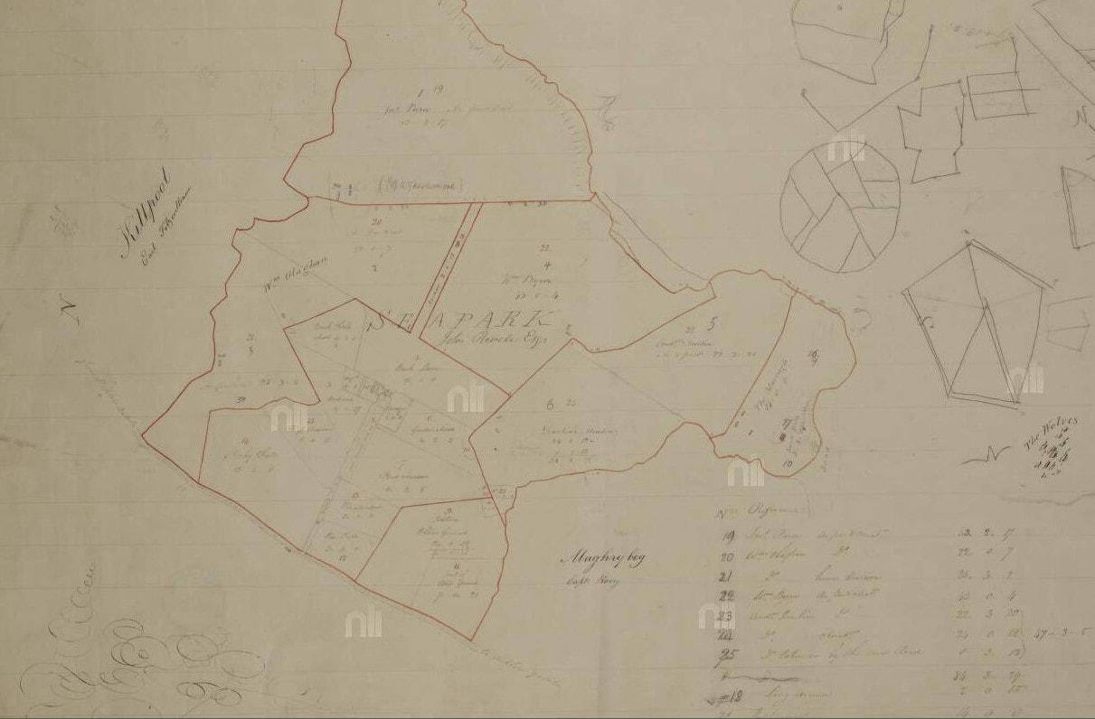 Seapark, Co. Wicklow for John Revell Esq. (click to enlarge)
The National Library of Ireland also has some map resources but they are buried deep within the catalogue. Try searching with "map" as a keyword and then restrict the results to Manuscript Maps in the Genre field on the right hand side - this generated nearly 2600 candidates the last time I tried it and many are digitised and freely available to explore and download.
The Longfield Map Collection is one wee gem I found here recently. This is a large collection of draft sketch maps made by a firm of cartographers for their clients between about 1770 and 1840. Probably best to try to filter results by county names to narrow down your selection. Some landowners names also appear in the catalogue entries, so you could also try a surname as a keyword. Or just browse and see what takes your fancy!
Although you have to be lucky to find something relevant, there are some lovely details in these sketches. For example, in addition to the clients for whom they were commissioned, you may well find adjacent land owners names too. Individual fields might be named and garden features described. Click on the image above right to see an example of what you might find.
Ordnance Survey Ireland
The modern site is designed to showcase the many digital mapping resources that this organisation can offer businesses. However, buried very deep within its pages are some historical maps that allow you to roam around Victorian Ireland.
You have to access these via their Geohive map viewer which I recommend you have a bit of a play around with to get used to. The UCD All Ireland maps link above gives you good instructions too but basically you need to;
The Ordnance Survey of Ireland also has a really nice application called the Irish Townland and Historical Map Viewer, which will allow you to search for townlands by name and view them on different underlying maps and even compare them with modern aerial photos. I've put together a page of basic instructions for getting started with using it.
The modern site is designed to showcase the many digital mapping resources that this organisation can offer businesses. However, buried very deep within its pages are some historical maps that allow you to roam around Victorian Ireland.
You have to access these via their Geohive map viewer which I recommend you have a bit of a play around with to get used to. The UCD All Ireland maps link above gives you good instructions too but basically you need to;
- Click the cross next to the "Base Information and Mapping" option in box in the left hand top corner
- Scroll down the list until you see the options prefaced "Historic".
- Choose one and enter your place name in the search box - it will tell you if it can't find the place, so you might need to think laterally. If you can, put in a fairly large recognisable town near the place you want to view and move the map around until you find the right spot.
The Ordnance Survey of Ireland also has a really nice application called the Irish Townland and Historical Map Viewer, which will allow you to search for townlands by name and view them on different underlying maps and even compare them with modern aerial photos. I've put together a page of basic instructions for getting started with using it.
You can also access the same OSI maps via the National Library of Scotland too, where you may find the functionality easier to use. Launched in SEP 2023, they currently have Ordnance Survey Ireland - Six-inch, 1829-1842, but have plans to add more in due course.

Another mapping resource compiled under open source is OpenStreetMap for Ireland. This is quite a technical site which is really designed to facilitate georeferenced data collecting and sharing. From the genealogist's point of view, it used to have a great way of accessing historic maps and a wonderfully simple tool that allowed you to switch on various layers e.g. townlands, parishes etc and have these clearly displayed over modern road maps.
Sadly, this appears to have gone in its latest guise - see more information at the bottom of my Townlands page for what it can show you now.
Sadly, this appears to have gone in its latest guise - see more information at the bottom of my Townlands page for what it can show you now.
The Royal Irish Academy (RIA) has published a series of historical maps in its Irish Historic Towns Atlas.
These are available online and have been grouped into collections relating to their common origins e.g., Viking, Anglo-Norman etc. (see the thumbnails at the foot of their page.)
There are a range of maps and supporting material available for each but be aware that these resources were primarily created as print products (which you can buy via their shop of course) and so, because of copyright restrictions, not all the printed material is made available online for free.
There is also a reference book that has been written to help you interpret the maps, sections of which are hyperlinked from the online home page, so be sure to read these before diving into the maps. The rest of the RIA site is also awash with information and essays, so worth exploring.
Another lovely publication replete with maps available from the RIA is "John Rocque's Dublin - A Guide to the Georgian City", which you can find out more about on my Bookshelves - Histories page.
The RIA also host the Digital Repository of Ireland which has a wide range of images from institutional collections covering the humanities, social sciences and cultural heritage. A good rummage around on this site may well reward you with some interesting images that you might find useful for your research.
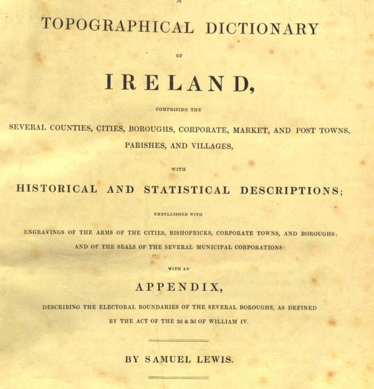
One particular resource that is a goldmine of geographical information is Samuel Lewis's Topographical Dictionary of Ireland, published in 1837. Original images of both volumes of this work plus a beautiful atlas of county maps are all available FREE to browse and download from the AskAboutIreland website - just click on the named link above. Some better resolution versions of these maps are also available via this FamilySearch's wiki page.
There is also the facility to search a transcript of this resource via the LibraryIreland site if you prefer but there are no maps on this site. Finally, be sure to check out the list of subscribers in the introductory pages of the dictionary as the great and good of Ireland (and selected diaspora) signed up to pledge funds and receive copies - I've found a few relatives in this list and also some good clues as to contemporary addresses.
Samuel Lewis must have inspired the powers that be to get a grip on all things topographical as a few years later along came the official Government versions. The actual titles are a bit more verbosely Victorian than these snappy links as you will see from the opening pages of the volumes I could find online. If you're prepared to settle in for a good read or hunt selectively within their pages, you may learn lots of wonderful facts to slay the pub quiz tournament or more importantly, track down an elusive ancestor's location;
The Placenames Database of Ireland (Logainm) is another great free site for finding places and locating them on simple maps. However, they also have some great map resources to download tucked away on their Historical Maps page. In addition to some beautifully etched maps of coastlines and maps of Irish language placenames, there are some very practical genealogical resources in the form of layers of administrative boundaries.
There are also plenty of sheets for various parts of many counties as well as some selected town plans e.g. Cork (1832), Waterford (1834) and Wexford Town Parishes (1838). All can be freely downloaded but some of them do become quite blurred when you zoom in.
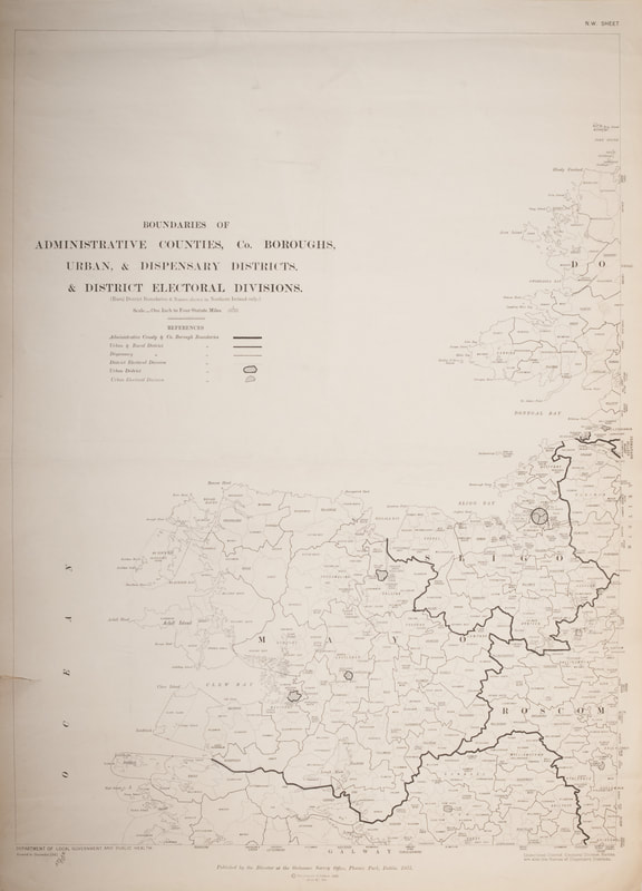
- North-East Administrative Boundaries
- North-West Administrative Boundaries
- South-East Administrative Boundaries
- South-West Administrative Boundaries
There are also plenty of sheets for various parts of many counties as well as some selected town plans e.g. Cork (1832), Waterford (1834) and Wexford Town Parishes (1838). All can be freely downloaded but some of them do become quite blurred when you zoom in.
Here are a few more miscellaneous map resources I've found elsewhere online, with Dublin well represented - have a good browse.
Historic Maps of Dublin Several different Victorian versions of the city, plus street indexes to some (Shane Wilson's site)
Dublin Historic Maps Good coloured maps showing administrative boundaries plus historical maps all shown as overlays on modern map
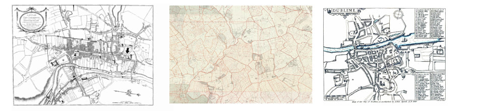
John Speed's Map of Dublin This is a beautiful little map, showing all the major churches and buildings in 1610 (see top right of this page)
Free Maps of Ireland Eclectic mix of historical and statistical maps
Historic Maps of Ireland Small selection of antique maps (Shane Wilson's site)
Historic Maps of Dublin Several different Victorian versions of the city, plus street indexes to some (Shane Wilson's site)
Dublin Historic Maps Good coloured maps showing administrative boundaries plus historical maps all shown as overlays on modern map
John Speed's Map of Dublin This is a beautiful little map, showing all the major churches and buildings in 1610 (see top right of this page)
Free Maps of Ireland Eclectic mix of historical and statistical maps
Historic Maps of Ireland Small selection of antique maps (Shane Wilson's site)
(c) Irish Geneaography - 2023
