Townlands
Lands but not necessarily with towns!
When tracing your family history in Ireland there's one bit of the geography you are going to have to wrestle with which I guarantee it will drive you to distraction at times - the townland. This is generally the lowest sub-division of the Irish landscape (although some sub-townlands do exist too.) There are more than 60,000 of them and they can vary hugely in size, from a few fields right up to whole mountains. Whilst many townlands do contain farms and settlements, a huge number are devoid of any buildings. They tend not to be used so much in the largest towns and cities where street names became more common in later records.
When tracing your family history in Ireland there's one bit of the geography you are going to have to wrestle with which I guarantee it will drive you to distraction at times - the townland. This is generally the lowest sub-division of the Irish landscape (although some sub-townlands do exist too.) There are more than 60,000 of them and they can vary hugely in size, from a few fields right up to whole mountains. Whilst many townlands do contain farms and settlements, a huge number are devoid of any buildings. They tend not to be used so much in the largest towns and cities where street names became more common in later records.
Why are they important?
You will find them referenced in virtually every historic record by way of an address. Without it, you will find it difficult to both find your ancestors in the records and make progress in differentiating between entries for common names.
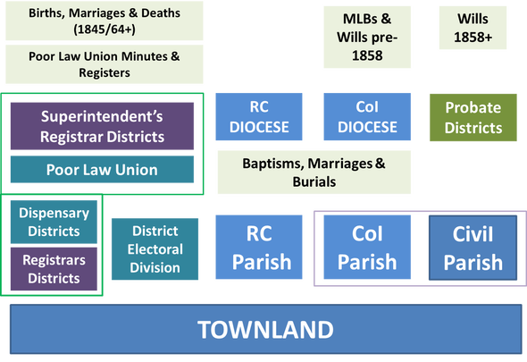
Townlands were also generally grouped together to form other geographic layers, both civil and ecclesiastical, as roughly portrayed below. You will need to know the names of those layers which your townland fell within in order to find the right records in the given record sets. The one ancient grouping I haven't attempted to include in this cartoon is the Barony, as it predates all of the others mentioned below and largely fell out of general use. Having said that, you will find them used in a host of land records and you will even need to know them for working out probate jurisdictions in the latter half of the 19th century, so don't ignore them when you come across them.
You will find them referenced in virtually every historic record by way of an address. Without it, you will find it difficult to both find your ancestors in the records and make progress in differentiating between entries for common names.
Townlands were also generally grouped together to form other geographic layers, both civil and ecclesiastical, as roughly portrayed below. You will need to know the names of those layers which your townland fell within in order to find the right records in the given record sets. The one ancient grouping I haven't attempted to include in this cartoon is the Barony, as it predates all of the others mentioned below and largely fell out of general use. Having said that, you will find them used in a host of land records and you will even need to know them for working out probate jurisdictions in the latter half of the 19th century, so don't ignore them when you come across them.
What's in a name? Cad ata in ainm? English or Irish? Depends when you're looking!
Townland names generally have their roots in a much older view of the landscape. Their boundaries and their names are often rooted in Gaelic descriptions of the terrain, which means there can be many repetitions of some townland names, both within and across counties. You will see lots of common prefixes originating from this same language root too e.g. "Bally", "Kil". English-speaking invaders probably struggled with some of these names and imposed many of their own when they appropriated the land, especially from the 17th Century onward. These are subject to the same issue of repetitions too - try searching for "Glebe" for example.
One of the first things to appreciate about townland names is that they have never been constant. Spellings changed over time and even at the same time - I've seen different spellings used within the same document! It can be hard to work out whether you are dealing with different spellings of a single townland or what might be 2 or more entirely different townlands. They might also have acquired prefixes and suffixes when they were split into smaller pieces (see my page on Rules for some examples and ideas for tackling this problem.) They might be qualified in some way, for example with a surname e.g. Aughanvanagh (Revell), very useful when trying to match up older land documents to newer maps.
There have been attempts to standardise townland names, particularly once the Victorians started implementing censuses (more on the available resources below.) Modern maps and gazetteers may even confuse you further. If the family history software you are using has a mapping feature, I'm going to bet my house that it will be based on sat nav data which is not going to be much use to you when you're trying to navigate back to the 18th century! Irish townlands are a real headache for these programs perhaps because there are no roads in many of them.
So, here are my Golden Rules to remember when hunting for a townland,
Trying to find a townland?
Where are you going to find out about townlands? There are 3 types of finding aids that are going to help you in your quest, namely, historical indexes, searchable databases and modern maps. You may find some combination of all three on some websites too.
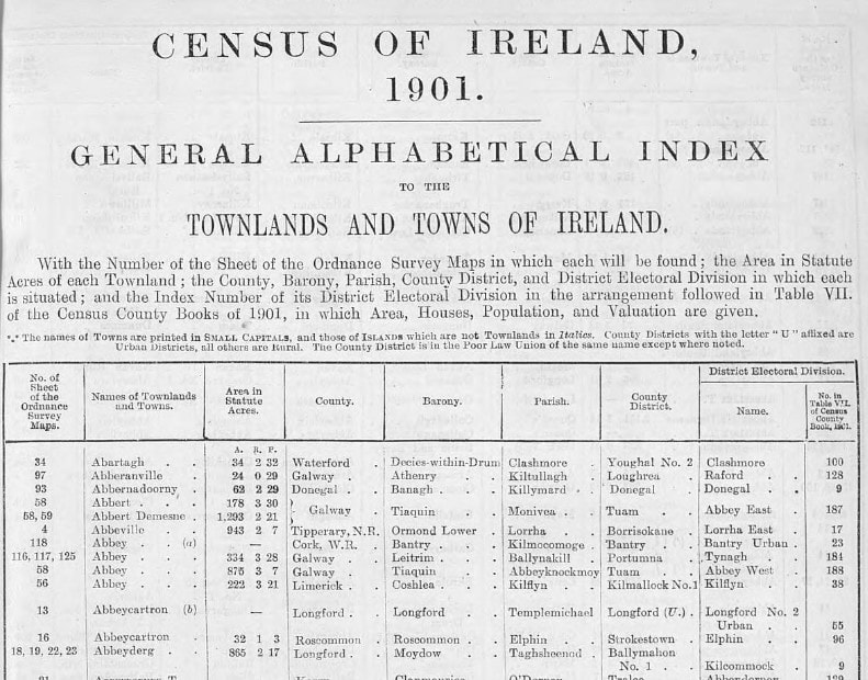
Several "General Alphabetical Indexes" were produced with reference to specific censuses. These can often be found as whole books to browse in various places online or the data has been incorporated into several searchable databases. For each townland you will also be able to find out which other geographical groups it was allocated to at the time as illustrated below.
Townland names generally have their roots in a much older view of the landscape. Their boundaries and their names are often rooted in Gaelic descriptions of the terrain, which means there can be many repetitions of some townland names, both within and across counties. You will see lots of common prefixes originating from this same language root too e.g. "Bally", "Kil". English-speaking invaders probably struggled with some of these names and imposed many of their own when they appropriated the land, especially from the 17th Century onward. These are subject to the same issue of repetitions too - try searching for "Glebe" for example.
One of the first things to appreciate about townland names is that they have never been constant. Spellings changed over time and even at the same time - I've seen different spellings used within the same document! It can be hard to work out whether you are dealing with different spellings of a single townland or what might be 2 or more entirely different townlands. They might also have acquired prefixes and suffixes when they were split into smaller pieces (see my page on Rules for some examples and ideas for tackling this problem.) They might be qualified in some way, for example with a surname e.g. Aughanvanagh (Revell), very useful when trying to match up older land documents to newer maps.
There have been attempts to standardise townland names, particularly once the Victorians started implementing censuses (more on the available resources below.) Modern maps and gazetteers may even confuse you further. If the family history software you are using has a mapping feature, I'm going to bet my house that it will be based on sat nav data which is not going to be much use to you when you're trying to navigate back to the 18th century! Irish townlands are a real headache for these programs perhaps because there are no roads in many of them.
So, here are my Golden Rules to remember when hunting for a townland,
- Do not get hung up on spelling (see my page on using Wildcards for some tips.)
- Be alert for repeated names, even within the same county. Never choose the first version you find - check them all out.
- Consider the time period that applies to your search and try to choose your finding aid accordingly.
Trying to find a townland?
Where are you going to find out about townlands? There are 3 types of finding aids that are going to help you in your quest, namely, historical indexes, searchable databases and modern maps. You may find some combination of all three on some websites too.
Several "General Alphabetical Indexes" were produced with reference to specific censuses. These can often be found as whole books to browse in various places online or the data has been incorporated into several searchable databases. For each townland you will also be able to find out which other geographical groups it was allocated to at the time as illustrated below.
- 1851 - The "General Alphabetical Index to the Townlands and Towns, Parishes and Baronies of Ireland" was based upon on the 1851 census and published in 1861.
- 1871 - "Census of Ireland, 1871 - Alphabetical Index to the Townlands and Towns of Ireland", published in 1877.
- 1901 - "Census of Ireland, 1901 - General Topographical Index", published in 1904. This shows which District Electoral Division the townland was allocated to, which is one of the layers by which the 1901 census is organised online.
For simple databases with some flexibility on how you search for a townland by name, there are 2 websites that spring to mind.
For more functionality and those all important maps, the following websites offer a choice of search interfaces and presentation of results.
- The IreAtlas Townland Database (aka SeanRuad) consists of a simple but versatile search box, particularly useful when you might only have a partial name from a transcription. You will be presented with some candidates and learn a little bit more about the other geographical layers that the townlands are allocated to. There are no maps and there is no further information to learn about where the original data came from and therefore what time period it might refer to, historical or modern. The database was first published in 1999 but has been updated as recently as 2023 - perhaps the author is trying to keep it current?
- The IGRS has a searchable database on the Index of Townlands, 1901. There are some good explanations on the history of the geography and a nice simple search function. The data is a sub-set of that illustrated above and I assume that the rest of it is available to members, or you can browse the book via the link above. There are no maps.
For more functionality and those all important maps, the following websites offer a choice of search interfaces and presentation of results.
- The Placenames Database of Ireland (Logainm) is an Irish government initiative (DTCAGSM) that is brilliant for finding townlands via their modern names and learning about their history. It helps you to navigate between Irish and English versions of selected place names and shows their location on simple maps. The Historical References will give you the most comprehensive range of different spellings and versions that have appeared in various documents over time (See my blog piece on how to include these historical names in your search.) There is even a function to hear how to pronounce the place name in Irish! The data is not just limited to townlands - lots of other named geographical features are also included, so if you come across an unfamiliar place in a document either in English or Irish, lob it into the search box on this site. If you are intrigued to learn more about where the Irish names originate, be sure to take a look at their Glossary & Distribution Maps where you can learn not only the meanings but also see a distribution of where the term is used across the island of Ireland.
- John Grenham's Irish Ancestors Placenames database will help you identify a townland and which civil parish it is in. You can also zoom in on the civil parish maps and see all the townlands contained within them. Even better, if you click on the parish name, you can also find out about surviving records. A recent blog post on his site suggests that John has taken his data from the 1851 index referenced above, but has had some headaches in trying to resolve dilemmas when combining the data with that available from modern OpenStreetMap for mapping.
- Irish Townlands - this site lets you search by modern names then highlights the townland on a simple map. Zoom out and you will get a better idea of where it is in relation to other places nearby. The bordering townlands feature is also really good although it would be even better if their labels could be on the map. The site appears to be run as a volunteer project and has covered a great deal of Ireland already - see their progress page for more details. It is closely coupled with the OpenStreetMap for Ireland project listed below and there is a lot of data to pick through. There is also a page called "Duplicate Names" which does appear to highlight how some of the same townland names crop up in different places, but the list is also dense with exact duplicate entries which seems to indicate more than one volunteer has mapped the same townland? I don't really know, as the site is great for data but short on explanations of it for those unfamiliar with the terms. Probably more useful for being aware of true duplicates in different places is their alphabetical Townland Index.
- Townlands of County Dublin - Brian Hollinshead has used OpenStreetMap to create a beautiful coloured overlay map of the modern townlands of this county (excluding the inner city of Dublin.) This is particularly useful for seeing how the Dublin suburbs have spread over what were once more rural townlands. Very simple but effective.
The Ordnance Survey of Ireland has a really nice application called the Irish Townland and Historical Map Viewer, which will allow you to search for townlands by the modern name and view them on different underlying maps and even compare them with modern aerial photos. I've put together a page of basic instructions for getting started with using it.
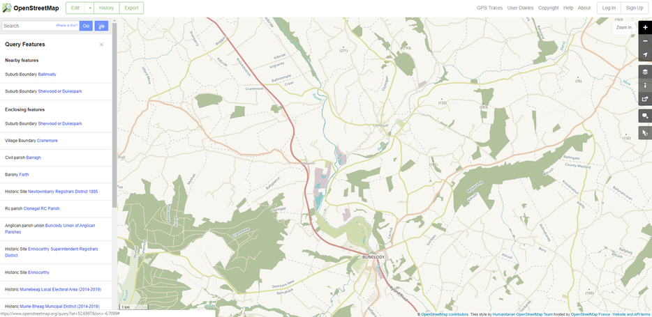 Image sourced from OpenStreetMap
I've mentioned some sites already that use the maps compiled under open source by OpenStreetMap for Ireland. This site is powered by a huge volunteer effort and is free to use but I am at a loss to understand who is directing the design and presentation of the information. When I first came across it, I loved it (see my blog story.) For example, there used to be a very simple way of identifying parishes and their townlands and an option to switch to historical maps that had lots of old detail on them too. However, sadly, this feature appears to have disappeared (or I'm proving particularly inept at finding it again!)
If you want to hear first-hand from someone who has worked a lot with this resource, then get a cup of tea and settle down to listen to Brian Hollinshead's National Library of Ireland 2016 talk about "Mapping townlands and other boundaries old and new". He gives some very useful insights into how the resource has evolved, highlights the problem of copyright and the difficulties of being precise with boundaries and names and waxes lyrical about the importance of detailed maps for many different purposes.
You can access the website using the link above, which should have the Humanitarian layer switched on. This should give you named boundaries when you zoom in but there appears to be a mixture of different levels all displayed as one layer now? One really annoying change is that instead of the townland names being neatly and logically labelled more or less in the middle of the townland, you have to hunt round the boundaries and squint sideways to read most of them now in tiny font * sigh *.
There is a function called "Query features", which you have to zoom in many times to activate. If you then click on it to turn it green and then click where you are interested in on the map with the "?" pointer active now, a panel will appear on the left hand side of the screen with a list of geographic layers to choose from (as illustrated above.). Click on any active blue link in the list and the named area will appear enclosed with a red boundary on the map. There is also a search facility on the main page now too.
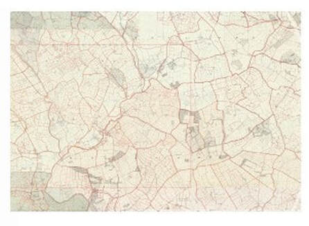 Contemporary map for Griffith's Valuations - image sourced via www.askaboutireland.ie
Once you've got your bearings and know the townland you're interested in, you can search for it via Griffith's Places on the AskAboutIreland website and then choose one of the map views. You will be able to zoom in on historical maps that have the townlands outlined in thick red lines. The picture will flicker between this version and a modern version as you zoom in and I believe you can use the slider to choose the composite view of old and new that suits your purpose. Unfortunately, on the historical maps, you'll have to squint a bit at the underlying faint text to make sure you're looking at the right townland and the maps are littered with parish names writ large across many townlands in bigger fonts too. However, you will be able to see the detail of buildings, field boundaries, roads etc.
Note, that although they accompany the Griffith's Valuation which was published between 1847 and 1864, these maps are believed to be older (possibly closer to the end of the 19th century), which means the spellings might not be exactly the same. You may also find that the field numbers do not exactly match up to those in Griffith's for the same reason.
(c) Irish Geneaography - 2023
